
Undergraduate students and researchers at The University of Alabama are making it possible to scan and image the bottom of waterways using light detection and ranging, or LiDAR, mounted on drones fitted with green lasers.
Dr. Seongsin Margaret Kim and her students are developing a system to make it faster and more affordable to measure and map the beds and floors of coastal areas, rivers and streams. LiDAR-equipped drones will allow researchers to quickly gather data of those underwater environments to calculate how flow rates and paths are changing.
“Our system we’re developing was started as a student senior design project where they successfully demonstrated water-penetrating LiDAR,” said Kim, UA professor of electrical and computer engineering.
There are several airborne systems on the market for bathymetry – the measurement of submarine topography – using traditional LiDAR technology. Those systems can cost more than $1 million and are designed to be used on airplanes that are unable to fly just above the water’s surface unlike drones. Kim’s LiDAR system reduces the size and power consumption needed so they can be used on the smaller drones at a fraction of the price.
“You can deploy them any time because if you have larger airborne systems, you have flight limitations and regulations to follow,” said Kim. “Those are going to be nearly minimized with the drones.”
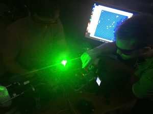
Kim’s group uses green lasers because the light’s wavelength can penetrate deeper into the water with lower absorption and provide high-resolution scans. By placing visual lasers on drones instead of airplanes, they can also safely operate at shorter distances from the surface.
“With some lasers you don’t actually see the light, but to make the water-penetrating LiDAR, you have to have use visual lasers,” said Kim. “Visual lasers sometimes need more regulations to the fly in the field outside because you can hit something or hurt someone.”
Bathymetry is the measurement of the depths and shapes of underwater terrain such as sea floors and riverbeds. According to Kim, the bathymetry of larger areas is usually measured by SONAR placed on boats and smaller locations by physical means with measuring sticks or other devices.
Multiple drones in a group, referred to as a constellation or swarm, can be quickly deployed on-demand to cover these areas instead and result in reduced manpower, time and cost.
“You can quickly see what’s happening, say, at the bottom of a river in terms of flow speed and location, and that data can then help with predictive water models,” said
The students are currently testing their equipment in a small tank and swimming pool where they were able to collect point cloud data on them. Point clouds are generated by LiDAR where each point represents a single laser scan measurement and are then stitched together creating a complete image of a scene.
The U.S. Geological Survey has experience mapping riverbeds, and Kim hopes this new technology can increase their partnerships with it and other federal agencies. Kim, Dr. Patrick Kung and Dr. Sevgi Gurbuz, both also from UA’s electrical and computer engineering program, were recently awarded a grant from the U.S. Navy to develop polarimetry LiDAR, which utilizes the polarization properties of light for better performance in underwater imaging.
“It all started as a student project, but now we are much ahead in competing to achieve a new innovation” said Kim.
With the Alabama Water Institute, National Oceanic and Atmospheric Administration and USGS all located on UA’s campus, Kim sees more opportunities for collaborations and for her students to get hands-on work for the project.
“My intention was to create a project that students actually can learn about the new things that we don’t teach in the classroom,” she said. “This is a really great chance for them to get experience with career developments and help them to enter the workforce.”